

The development of cities and the enhancement of infrastructure depend on the clarity of visual information. The digital maps allow the planners, architects and developers to interpret the physical world and make decisions based on accuracy. All boundaries, contours, and structures need to be modeled accurately to make accurate sound decisions. The combination of large-scale mapping and street-level images empowers professionals with more insight into context that cannot be captured by two-dimensional maps.
Elevating Detail with High-Precision Mapping
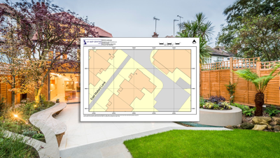
A 1:200 scale map delivers one of the most detailed perspectives available for planning and design. At this scale, a single centimeter on paper represents two real-world meters, offering remarkable insight into the spatial arrangement of buildings, driveways, and access routes. Such precision allows surveyors and engineers to review dimensions, boundaries, and proximity relationships without ambiguity. When used within planning applications, these maps communicate the full physical setting clearly, helping regulatory bodies and stakeholders visualize proposed changes with confidence.
Complementing Maps with Ground-Level Perspective
Top-down mapping is logical in explaining layout, but fails to show the nuances of an environment. The limitation can be overcome by using street-level imagery, like that of OS StreetView, which provides a ground-level perspective. The representation of elevation, vegetation, entrances, and materials around gives a feeling of the depth to technical information. With these integrated resources, the planners will be able to read the terrain, scale, and character without having to visit the site several times, which saves time and cost.
Enhanced Accuracy through Layered Insights
Superimposition of the mapping data and street imagery creates a multidimensional reference model. Through the comparison of the measurements made on the maps and the visual information obtained at ground level, discrepancies or missing details can be identified. As an example, topographic alterations that may not be reflected on a flat map can be identified by the perspectives of images. On the same note, conflicts that might arise between any proposed developments and the current utilities can be raised at an early stage. This consolidation of datasets enhances compliance and vision when submitting plans.
Simplifying Site Assessment and Review
Developers are often faced with the challenge of assessing more than one potential site at a time. The integration of accurate mapping and panoramic imagery enables every destination to be visited without the need to be physically present. The pavements, boundary fences or other structures nearby can be viewed and compared without the need to travel physically. It is especially useful in cases where the area of the project is large, or partners are located in various locations. Remote assessment is not a substitute of fieldwork but rather a well-informed starting point that narrows down further inspections.
Supporting Transparent Planning Submissions
Planning authorities rely on clarity and verifiable evidence to assess proposals. Layered spatial data communicates ideas unambiguously. When applications include detailed mapping and accompanying imagery, decision-makers gain both technical and visual assurance. The ability to cross-reference real-world conditions within the same digital environment reduces ambiguity and supports faster review cycles. Moreover, residents and community members can engage more easily when visual information reflects the true environment they recognize.
Streamlining Collaboration Across Teams
Architects, engineers and environmental consultants all have different expertise in complex development projects. By organizing their activities with reference to the same integrated mapping platform, misinterpretation can be avoided. Layered visualization tools enable professionals to annotate, measure and model changes in a collaborative manner. Both in refining boundary alignments and in establishing possible barriers, common visual references promote more coordination and reduced deviations. Planning outcomes are enhanced significantly when all the contributors view the same data in complementary formats.
Encouraging Sustainable and Informed Design
Beyond regulatory compliance, combining large-scale maps with street imagery promotes design sensitivity. Understanding how a proposed structure interacts with existing streetscapes encourages thoughtful placement and proportion. Designers can anticipate sunlight angles, drainage considerations, and pedestrian access from the real-world context. With both macro and micro perspectives available, development decisions become grounded in tangible environmental awareness. This integrated approach contributes to smarter, more sustainable planning outcomes that respect both landscape and community.
Preparing for the Next Era of Digital Mapping
The development of geographic information systems has continued to reshape the interaction of professionals in space. The combination of mapping accuracy and real-life photography is just the tip of the iceberg. With the emergence of three-dimensional visualization and real-time data layers, planners will be working in fully immersive spatial environments. These emerging technologies are likely to facilitate easier decision-making, so the changes of the future will be more balanced in terms of usefulness, innovation, and environmental protection.
A New Standard for Planning Intelligence
The planners are provided with a potent interpretation and communication tool by integrating precise mapping with street-level data. The technological system is led by accuracy and human understanding is supported by visual evidence. Together, they establish a new level of accuracy and efficiency of the planning process, and every decision is supported by facts and experience.
(0) comments
We welcome your comments
Log In
Post a comment as Guest
Keep it Clean. Please avoid obscene, vulgar, lewd, racist or sexually-oriented language.
PLEASE TURN OFF YOUR CAPS LOCK.
Don't Threaten. Threats of harming another person will not be tolerated.
Be Truthful. Don't knowingly lie about anyone or anything.
Be Nice. No racism, sexism or any sort of -ism that is degrading to another person.
Be Proactive. Use the 'Report' link on each comment to let us know of abusive posts.
Share with Us. We'd love to hear eyewitness accounts, the history behind an article.